Recent Storm Damage Posts
Hurricane Preparedness Week
5/4/2022 (Permalink)
Being prepared is one of the best things you can do for your family.
- Determine your risk- Get familiar with your area by determining the risk or treat from a hurricane. Winds, storm surges, and tornadoes.
- Develop an evacuation plan-Get familiar with your evacuation zones and alternate routes in case flooded areas and falling trees obstruct the road.
- Make an emergency disaster kit-Be prepared with a kit that has flashlight and batteries, radio, and enough non-perishable food and water to last a couple of days for each person.
- Strengthen your home- Cover windows, trim trees, secure loose outdoor items, secure all doors, and move your car to a safe location
- Check on neighbor-Offering a helping hand with one or more of the above and also checking on them after the storm.
Lessen the damage by checking after a hailstorm
4/27/2022 (Permalink)
Depending on the size of the hail in a hailstorm makes all the difference in the size of the damage. A fast response lessens the damage, limits further damage, and reduces the restoration cost. When storms hit the Wilson or Nashville N.C. area, we can scale our resources to handle a hailstorm. When checking for damage be careful, safety always comes first.
After hailstorm hits check your home for the following:
Window -Dented frames, broken or shattered glass, damaged screens.
Roofs- may not notice damage from hail at first, but after a hailstorm you may have leaks from your damage. Hail dents, crack in shingles
Gutters- May eventually cause damage to the foundation to your home. Hail can dent, screens or downspouts. Also, hailstorm can cause debris to clog the gutters.
Difference between Tornado Warning and watch:
4/19/2022 (Permalink)
Tornado Warning
A warning is issued when a tornado is occurring, imminent or likely. A tornado warning means weather conditions pose a threat to life or property. People in the path of the tornado need to take protective action.
Tornado Watch
A watch is used when the risk of a tornado has increased significantly, but its occurrence, location or timing is still uncertain. It is intended to provide enough lead time so those who need to set their plans in motion can do so. A watch means that a tornado is possible. People should have a plan of action in case a storm threatens and they should listen for later information and possible warnings especially when planning travel or outdoor activities.
SERVPRO of Wilson/Nashville is locally owned and operated, we are able to respond quicker with the right resources, which is extremely important. A fast response lessens the damage, limits further damage, and reduces the restoration cost.
Storm tips
3/31/2022 (Permalink)
SERVPRO of Wilson/Nashville is locally owned and operated, we are able to respond quicker with the right resources, which is extremely important. A fast response lessens the damage, limits further damage, and reduces the restoration cost.
Without warning, a storm can damage you home. High wind event can damage your home, windows, roof with shingles, siding.
High winds can also, blow debris at windows causing them to break, or to crack. Install storm shutter as a preventative measure.
Tie down loose objects like grills, dog houses, and chairs.
Keeping trees trimmed, may help prevent a tree limb falling and damaging your home.
SERVPRO of Wilson/Nashville specializes in storm damage restoration. Our crews are highly trained, and we use specialized equipment to restore your property to its pre-storm condition.
Have Storm Damage? Call Us Today (252)-291-4492
Check list after the storm
3/22/2022 (Permalink)
Since we are locally owned and operated, we are able to respond quicker with the right resources, which is extremely important. A fast response lessens the damage, limits further damage, and reduces the restoration cost. Prolonged water damage to your home’s structure can be dangerous if not addressed. After a storm when you can safely inspect your home, check the following:
Check your home after a storm:
Make sure your gutters are free from debris
Checking your ceiling for leaks, sagging or bubbling dry wall, slight discoloration, and water stains.
Check roof for cracks, damaged or missing shingles, and visible debris.
Check the exterior walls, discoloration, cracks, or dents.
Check windows, for broken pains or damage to the frame.
Check crawlspaces for standing water.
Have Storm Damage? Call Us Today (252)-291-4492
Helpful Weather Terms
5/4/2021 (Permalink)
HURRICANE/TROPICAL STORM EVENTS:
Tropical Depression:
An organized system of clouds and thunderstorms with a defined surface circulation and maximum sustained winds of 38 MPH (33 knots) or less. Sustained winds are defined as one-minute average wind measured at about 33 ft (10 meters) above the surface.
Tropical Storm:
An organized system of strong thunderstorms with a defined surface circulation and maximum sustained winds of 39–73 MPH (34–63 knots).
Hurricane:
An intense tropical weather system of strong thunderstorms with a well-defined surface circulation and maximum sustained winds of 74 MPH (64 knots) or higher.
Storm Surge:
A dome of water pushed onshore by hurricane and tropical storm winds. Storm surges can reach 25 feet high and be 50–1000 miles wide.
Storm Tide: A combination of storm surge and the normal tide (i.e., a 15-foot storm surge combined with a 2-foot normal high tide over the mean sea level created a 17-foot storm tide).
Helpful Weather Terms
4/27/2021 (Permalink)
Weather can be unpredictable, always prepare for the unexpected. Storm may cause power outages due to fallen trees, lightning striking power lines or your home. Keeping up to date with the weather and knowing the weather terms may help prepare you for storms.
Basic Weather Terms:
Warning
A warning is issued when a hazardous weather or hydrologic event is occurring, imminent or likely. A warning means weather conditions pose a threat to life or property. People in the path of the storm need to take protective action.
Watch
A watch is used when the risk of a hazardous weather or hydrologic event has increased significantly, but its occurrence, location or timing is still uncertain. It is intended to provide enough lead time so those who need to set their plans in motion can do so. A watch means that hazardous weather is possible. People should have a plan of action in case a storm threatens and they should listen for later information and possible warnings especially when planning travel or outdoor activities.
Advisory
An advisory is issued when a hazardous weather or hydrologic event is occurring, imminent or likely. Advisories are for less serious conditions than warnings, that cause significant inconvenience and if caution is not exercised, could lead to situations that may threaten life or property.
Be prepared for hurricanes
4/19/2021 (Permalink)
Hurricane season is approaching, so now is the perfect time to start planning for what to do if there is an incoming hurricane. Taking steps to ensure you and your family’s safety. Some helpful tips and reminders are to:
Have an evacuation plan- Get familiar with your evacuation zones and alternate routes in case flooded areas and falling trees obstruct the road.
Make an emergency supply kit- Flashlight and batteries, food, water, and some personal necessities. Important documents, prescription and non-prescription meds, and first-aid kit.
Prepare your home- Look for weak spots in your home where wind or rain can enter your home.
SERVPRO of Wilson/Nashville specializes in storm and flood damage restoration. Our crews are highly trained, and we use specialized equipment to restore your property to its pre-storm condition.
Faster Response
Since we are locally owned and operated, we can respond quicker with the right resources, which is extremely important. A fast response lessens the damage, limits further damage, and reduces the restoration cost.
http://www.SERVPROwilsonnashville.com/storm-flooding-restoration
Preparing for the unexpected!
4/1/2021 (Permalink)
When weather is concerned expect the unexpected. Tornadoes for example, can be one of the most unexpected events during strong thunder storm. For this very reason tornado warnings are posted for certain time intervals to keep you informed.
Preparing for the storm
- Be familiar with signs of a tornado
- Sign up for weather alerts
- Pay attention to the weather in your area
- Develop an escape plan
During a storm event know where to go in the structure you are in for safety. Wither it a school, manufactured home, commercial building or vehicle. After the storm, be careful when you are checking for damage, sharp objects and debris. If you are unsure of your safety in a structure because of the damage, seek a safe shelter.
Let's talk Storms
3/22/2021 (Permalink)
SERVPRO of Wilson/Nashville specializes in restoration from storms. Our crews are highly trained, and we use specialized equipment to restore your property to its pre-storm condition. Since, we are locally owned and operated, we can respond quicker and with the right resources, which is extremely important. A fast response lessens the damage, limits further damage, and reduces the restoration cost. When storms hit the Wilson or Nashville N.C. area, we can scale our resources to handle a large storm.
Places in homes or businesses to check after storms (Lightning, wind, hail, tornadoes, or Hurricanes.)
- Roof: cracked, damaged, or missing shingles, and visible debris.
- Chimney flashing and gutters
- Ceilings: leaks, sagging or bubbling dry wall, slight discoloration, and water stains
- Exterior walls and windows for damage
http://www.SERVPROwilsonnashville.com/storm
Have Storm Damage? Call Us Today (252)-291-4492
Prepping for Hurricane Season
5/6/2020 (Permalink)
As some of you may know, Eastern North Carolina is an area that can be greatly affected by hurricanes. The official “Hurricane Season” lasts from June 1-November 30. As summer quickly approaches, now is the perfect time to start making a plan for what to do if there is an incoming hurricane. Taking some time to plan now will keep you one step ahead and will help ease your stress and worry if the time comes to take action. Some helpful tips and reminders are to:
- Determine your risk-Hurricanes bring hazards to coastlines and inland areas including storm surge, inland flooding, tornadoes, and strong winds
- Develop an evacuation plan-Find out today if you live in a hurricane evacuation zone. Plan your route out and follow evacuation orders. Be sure to plan for your pets as well
- Assemble disaster supplies-Get your supplies before hurricane season begins, including batteries, radios, chargers, and enough food and water for each person for 3 days. Fill your prescriptions and have medicine on hand. Fill your vehicle with gas and have cash on hand
- Insurance check up-Check in with your insurance agent well in advance to prepare your home and vehicles properly
- Strengthen your home-Cover windows, trim trees, secure loose outdoor items, secure all doors, and move your car to a safe location
- Help your neighbor-Many people rely on assistance from neighbors before and after hurricanes. Help your neighbors prepare and/or evacuate and check in with them after the storm passes
For more tips and information on creating a plan visit https://www.ready.gov/make-a-plan
Spring and Summer Storms can be Beautiful, but Dangerous
4/20/2020 (Permalink)
 SERVPRO is ready to help in the event a storm damages your home or business.
With the weather heating up in Eastern North Carolina it is starting to feel like Summer, but this also brings increased chances of threatening storms. Spring and Summer storms can pose a risk for flooding, damaging winds, and possible hail.
Make sure to stay updated with your local weather station to make a plan for any disaster. Take extra precaution to prepare for flooding if you live in or near a flood zone or low lying area. In the event of strong winds, keep an eye on large trees that are close to your home.
Flooding and water emergencies don’t wait for regular business hours and neither do we. SERVPRO of Wilson/Nashville provides emergency cleaning and restoration services 24 hours a day, 7 days a week—including all holidays. We hope everyone stays safe as these storms become more frequent, but we are always ready to help our community in an emergency situation.
SERVPRO is Here to Help During Storms or Floods
4/1/2020 (Permalink)
SERVPRO of Wilson/Nashville specializes in storm and flood damage restoration. Our crews are highly trained and we use specialized equipment to restore your property to its pre-storm condition.
Since we are locally owned and operated, we are able to respond quicker with the right resources, which is extremely important. A fast response lessens the damage, limits further damage, and reduces the restoration cost.
When storms hit, we can scale our resources to handle a large storm or flooding disaster. We can access equipment and personnel from a network of thousands of franchises across the country and elite Disaster Recovery Teams that are strategically located throughout the United States.
If you experience damage to your home or business from a flood or storm, give us a call!
252-291-4492
What To Do If You Have A Leaky Roof
3/19/2020 (Permalink)
Eastern North Carolina experiences frequent rain and storm damage. If your roof is not properly maintained, it can be more prone to leaks during times of rain and strong wind. It is important to keep up with roof maintenance, as a leaking roof causes the water to damage not only the roof, but the inside of the building. Prolonged water damage to your home’s structure can be dangerous if not addressed. If the inside of your home or business is wet due to a leaking roof, you must contact a qualified roofer first. As in all other cases of water damage, the cause of the leak must be fixed first to prevent more damage from the same source. Once the cause of the leak is fixed, SERVPRO of Wilson/Nashville can dry out the inside of your home in no time.
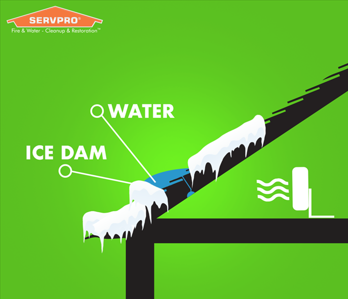
Ice Dam Cause and Effect
1/20/2020 (Permalink)
 Remove wet materials near the affected area and place a fan to slow the leak and amount of damage until help arrives.
An ice dam is the ridge of ice that forms at the edge of a roof which prevents melting snow from draining as it should. Typically during the winter season, the temperature on the interior of the house is turned up to keep the inside warmer. As the heat rises and escapes into the highest level of your structure (typically the attic), the snow on the peak of the roof starts to melt. The water runs down the roof and begins to pool and refreeze the further away it gets from the heat source. This is why it is most common to see dams forming on the edges of roofs or in the gutters.
Effects of an Ice Dam
Ice dams cause leaks when snow melts higher on the roof and that melt water hits a ‘dam’ of ice. With nowhere else to go, the water is forced to back up under the roofing materials and into the structure. Ice dams cause water to pool and seep under shingles. The wet building materials cannot dry out quickly enough to keep mold from growing.
There are plenty of warning signs that your house will exhibit to alert you to a possible ice dam.
- You see long/large icicles forming on the edge of the roof, or off the front edge of the gutter
- Ice is coming through the soffit of your roof
- Ice is forming behind the gutters
- You see ice or water on the exterior wall
- You see water coming through the frame of a door or window
- You see water coming through the ceiling or interior wall
Now that you are armed with this knowledge, you can prepare for this winter. Do some research on preventative maintenance, find a quality roofer, and keep SERVPRO of Wilson/Nashville on your speed-dial!
Looming Hurricane Season A reminder that NC must do more to Mitigate flood risk
6/13/2018 (Permalink)
 Green shaded area on map represent flood zone for Tar River. Most of Nash County and part of Wilson County fall in that zone.
WRAL Weather News:
"The early season warning delivered by Subtropical Storm Alberto – that North Carolina is especially susceptible to storm surge and flooding – coincides with a series of state studies examining how to prevent or alleviate future catastrophic events.
Hurricane season officially {started June 1st}, marking almost two years since Hurricane Matthew produced the catastrophic rain that filled rivers and streams and swamped homes and communities along the Tar River, to the tune of over $100 million in damages. For towns like Princeville, Tarboro, Rocky Mount and Greenville, it was the second "once-in-a-lifetime" storm to hit in 19 years.
The state agrees, and North Carolina Emergency Management has been working on solutions that go beyond raising or moving buildings and building higher levees. The studies also look for ways to slow down the flooding well upstream.
One idea is to ease the pressure on rivers, slowing flooding before it spreads.
North Carolina Emergency Management Assistant Director John Dorman outlined a plan to build wet reservoirs – essentially new lakes – along the Tar and at the top of Fishing Creek, and/or to establish dry reservoirs on Stony and Swift creeks, simple, low-lying areas that can be used as ballfields and parks, but when catastrophic rain falls, then can collect water like reserve bathtubs.
"You basically allow the water to raise up, but you've got the drain. The drain doesn't let all the water run out at one time, it runs out slowly," Dorman said.
Improvements could cut the cost of a future Hurricane Matthew-level event by more than half, but they'd be costly to implement. Buying and building the detention areas would cost tens of millions of dollars and take decades. And structures in the floodplain would still need to be elevated or moved.
The decisions will be made by state and local leaders, but the data gives them many options to consider.
For residents tired of the Tar River's rising water, any and every option is welcome news to keep history from repeating.
"We have struggled for so long in eastern North Carolina," said Princeville Mayor Bobbie Jones.
https://www.wral.com/flash-flooding-likely-as-alberto-brings-heavy-afternoon-rain/17587209/
Winter Storm Grayson
1/30/2018 (Permalink)
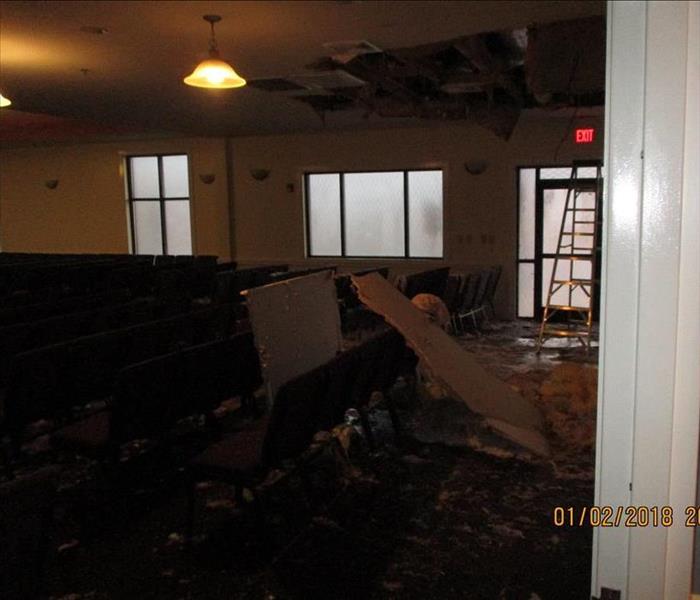 A Class 3 Water Damage, most likely came from overhead and virtually saturated the materials in the entire area.
Thanks to our dedicated SERVPRO Employees, we have succeeded in delivering the customers fast and effective Mitigation & Drying Services in the Wilson & Nash County areas that have been immediately affected by Winter Storm Grayson.
Commercial Companies, large and small, have been significantly impacted by the extremely cold weather that this Coastal storm brought to Eastern North Carolina. Companies, such as BB&T, had suffered a massive water damage when their sprinkler system froze and burst. It had caused tons of gallons of water to dump over at least 1/4 of the first floor. A few of the technicians reported being "ankle-deep in water" where several inches of water had accumulated rapidly over the entire affected area. A job that had started at 3:00/3:30 PM in the afternoon took several hours to mitigate keeping our crews working well into the evening.
A couple other Commercial properties suffered a similar fate. One Customer in particular had some wonderful feedback and praises for the After Hours Emergency Response Team that travelled to his Commercial property at 4:30/5:00 AM where a broken pipe had been pouring water out of the ceiling and onto the floor. Virtually the entire structure had been affected with water. The team stayed on-site well into the late morning extracting water and laying out drying equipment as an attempt at keeping businesses open and running. This yielded successful results.
A large number of Residences sustained both major and minor water damage to their homes. The most common cause of loss reported was frozen pipes in the Attic. As the temperature is predicted to fluctuate for the next week or more, we predict there will be more damages to occur and even more secondary damages. If you have not already gathered supplies or did not have enough to prepare it is important to make note of what will be needed and stock up for the next time a storm such as this comes around. It is only the beginning of January, chances are there will be another opportunity.
FREE Emergency Ready Profile - Storm Season Preparedness
9/20/2017 (Permalink)
 Contact your local SERVPRO Office for more information regarding this FREE Service.
Let me ask you something, imagine if you're at lunch and suddenly you get a panicked call from the office because there is a gas leak, or maybe water is pouring out of a broken pipe under the sink. Would you be able to direct them how to shut-off the gas or water? Whether you are away for lunch, on vacation, or if it's after hours, wouldn't it be nice to have access to your vital building data and emergency contact information directly from your smart phone, 24/7? SERVPRO has developed a convenient application that organizes this information for you...all at your fingertips!
SERVPRO is a national sponsor of the American Red Cross' Ready Rating program, and as part of our community service, we are helping local businesses prepare for disasters. The application is also available for residents, call today for more information!
We are having an active Hurricane season this year, will you be ready?
SERVPRO of Wilson/Nashville - 252-291-4492
When Storms or Floods hit Eastern North Carolina, SERVPRO is ready!
3/22/2017 (Permalink)
 Our FREE Emergency Ready Profile is a great remind that we are only a phone call away, especially during a disaster. Call and ask about it today!
SERVPRO of Wilson/Nashville specializes in storm and flood damage restoration. Our crews are highly trained and we use specialized equipment to restore your property to its pre-storm condition.
Faster Response
Since we are locally owned and operated, we are able to respond quicker with the right resources, which is extremely important. A fast response lessens the damage, limits further damage, and reduces the restoration cost.
Resources to Handle Floods and Storms
When storms hit the Wilson or Nash County area, we can scale our resources to handle a large storm or flooding disaster. We can access equipment and personnel from a network of 1,650 Franchises across the country and elite Disaster Recovery Teams that are strategically located throughout the United States.
http://www.SERVPROwilsonnashville.com/storm-flooding-restoration
Have Storm or Flood Damage? Call Us Today (252)-291-4492


 24/7 Emergency Service